
White Sands, Carlsbad Caverns, Guadalupe Mountains, and Big Bend Itinerary: The Ultimate Southwest National Parks Road Trip

Every once in a while, a road trip surprises you with just how alive it makes you feel. This White Sands, Carlsbad Caverns, Guadalupe Mountains, and Big Bend itinerary became one of those trips for our family – early mornings, glowing dunes, caves that swallow sound, fossil beds, river days, and night skies so bright you swear the stars are closer.
This is exactly how our 2023 Spring Break unfolded — logistics, reservations, trail details, where we slept, and the moments we’re still talking about.
You can follow it day by day or mix and match depending on your own pace to make your own White Sands, Carlsbad Caverns, Guadalupe Mountains, and Big Bend itinerary.
Day 1: White Sands National Park
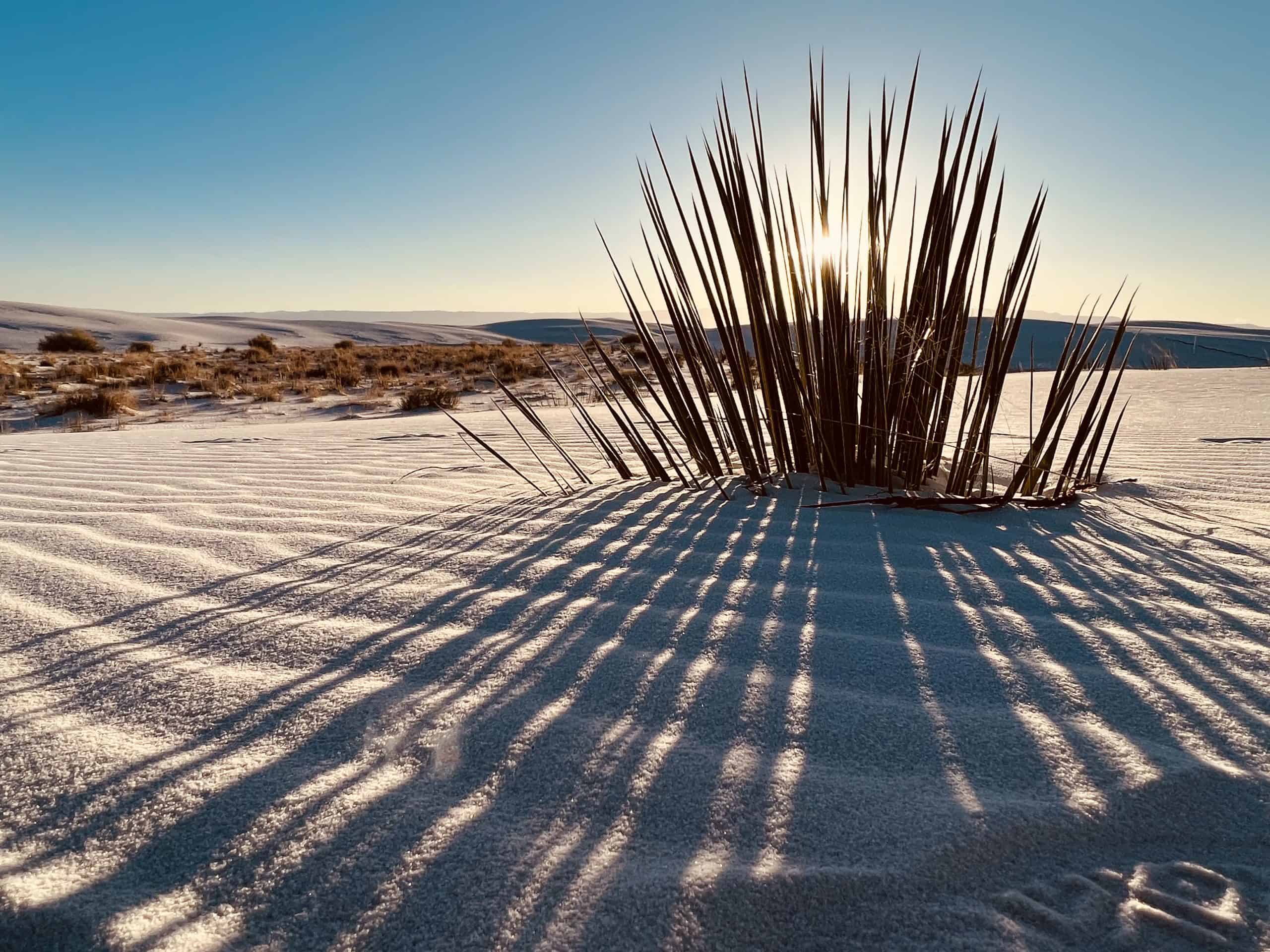
There is nothing in the world like stepping into White Sands just after sunrise. The dunes glow, the sand is cool, and you feel like you’re walking on the surface of the moon, only softer.
We were waiting in line when the gates opened at 7:00 AM! This gave us plenty of time to explore the Dunes Drive (16 miles round trip), sled down the dunes, run the ridges, and soak in the quiet before the visitor center opened at 9:00. After getting our passport stamp and souvenirs, we headed out around 9:30 for a 1:00 arrival at Carlsbad.
Tip: Check the local Walmart for sleds the night before. The visitor center sells them but they’re often cheaper in Alamogordo. We opted to wax the bottoms of ours from home!
Day 1 Continued: Carlsbad Caverns National Park
Carlsbad is one of those parks where planning ahead pays off. Reservations are required and time slots book quickly.
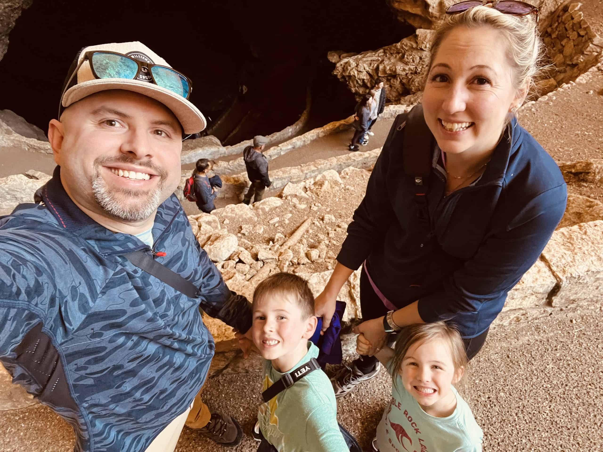
Our self-guided tour reservation was at 1:30, so our 1:00 arrival was perfect. After a brief orientation, we headed down through the Natural Entrance to experience the different cave zones from the entrance to twilight, transition, and finally the dark zone. This trail is 1.3 miles and takes about 1 hour to make it to the bottom. It is steep, but absolutely magical and definitely a unique way to start your cave exploration!

Once you make it to the bottom, hike the 1.2 mile trail through the Big Room. This is truly one of the most awe-inspiring rooms within any cave I’ve seen. When it opens up, take a moment to just look around you. Realizing this massive room is all underground is mind blowing!
At the end, you can either hike back up the Natural Entrance (remember it’s steep!) or take the elevator back up the 750′ like we did. The last ride up is at 4:45, so plan accordingly.
Day 2: Carlsbad Caverns to Guadalupe Mountains
Carlsbad Caverns
The next morning, we had planned on doing the King’s Palace Tour which is the most popular ranger-guided tour, but we were unable to get reservations. So, if you want to go to the deepest part of the cavern to explore four highly decorated chambers, get on the site first thing when reservations open. As of the time of this post, unfortunately this tour isn’t being offered, but keep an eye out!
Guadalupe Mountains
From Carlsbad, it’s a quick, beautiful 44 minute drive to Guadalupe Mountains National Park, a park that often gets overshadowed but absolutely shouldn’t. The mountains rise suddenly from the desert, and the trails here feel wild and untouched.
What we did:
- Frijole Ranch History Museum
- Smith Springs Trail
- 2.3 miles, 1 – 2 hours, moderate
- Pine Springs Visitor Center
- Pinery Nature Trail

We stopped at the Frijole Ranch Museum first. After a perfect lunch at the picnic tables, we explored the house, schoolhouse, and spring house before heading out on the Smith Springs Trail. This 2.3 mile hike was the first “big” hike our kids had done. Until that point, we hadn’t done anything more than a mile. A desert oasis with a beautiful waterfall sounded like a wonderful break before bribing them with a trip to the visitor center to finish out the trail. It took us about 2 hours total, but if you have longer legs and less playtime, you could make it closer to 1 hour.

After a stop at the Pine Springs Visitor Center for our passport stamp, we walked less than a mile along the Pinery Nature trail to see the Butterfield Stagecoach ruins. That evening, we stayed at El Capitan in Van Horn. This historic hotel designed by Henry Trost was our second oasis for the day!
More Guadalupe Mountain Hikes
- Devil’s Hall
- 4.2 miles, 3 – 5 hours, strenuous
- Guadalupe Peak Trail
- 8.1 miles, 6 – 8 hours, strenuous

There are several other hikes that we were interested in, but our kids just weren’t up for it that day. Two of those were Devil’s Hall and Guadalupe Peak Trail. Lucky for you, my good friend, Jess and her family, made the trek during their National Park adventure. When I asked her what she thought about these hikes, she graciously told me all about it.
“We arrived at Guadalupe, took the obligatory National Park sign picture and began our trek on Devil’s Hall. Devil’s Hall is a 4.2 mile out and back rock scrambling trail. While it is considered “strenuous”, our freshly turned 6-year-old daughter and 10-year-old son were able to complete this hike without a problem. In fact, this is our favorite family hike of all time.

The first mile is quite boring – just a desert mile hike and both kids were asking to turn around and head back to the car. Once the boulders appeared, the kids loved the adventure of finding their own path across the large boulders. We could not believe the grit and determination we saw from our kids, climbing over the large boulders and paving their way through the trail. I can’t tell you how many times I looked at my husband in awe and said “I am so proud of them!”
Cell service is limited and the trail is not well marked so I recommend downloading the route on AllTrails before venturing out. There is a natural wall staircase that seemed very daunting, but we took it slow and it wasn’t a problem. At the halfway point, we had gone through ¾ of our water and realized we needed to start rationing it. We had an adult-sized camelback, two child sized camelbacks, and a 32 oz water bottle. For reference, we went in early April, so if you are traveling in late spring or summer, keep this in mind. We all felt very accomplished after the hike and immediately found water and ice cream… because how else are you going to complete a strenuous hike without the promise of ice cream to little ones?
While I really wanted the entire family to complete Guadalupe Peak Trail, a challenging 8.1 mile roundtrip with a 3,000 foot elevation gain hike (Texas’s highest point), I knew our 6-year-old daughter wouldn’t enjoy it. We want to instill a love for nature and hiking into our kids and forcing them beyond their capability is not the way to do it.

While mom and sis had a relaxing pool day recovering from Devil’s Hall, dad and son ventured out for the ultimate challenge. They set off early in the morning to avoid the Texas heat, with plenty of snacks and water. The 10-year-old handled the strenuous hike and frightening cliffs like a champ, often telling dad to hurry up. It was a fantastic bonding experience and a day they will never forget. We all celebrated their accomplishment with a steak dinner. To this day, when things get hard, I tell him “You can do hard things, you hiked Guadalupe Peak, didn’t you?”
Day 3: Big Bend National Park – First Stops

Our First Stops:
- Fossil Discovery Exhibit
- Big Bend Entrance Sign
- Panther Junction Visitor Center
- Panther Path: 0.2 miles, quick and easy
- Grapevine Hills to Balanced Rock
- 2.2 miles, 1 hour, moderate
We headed out early from Van Horn and headed 3.5 hours south to Big Bend National Park. Our first stop was the Fossil Discovery Exhibit which the kids absolutely loved! Here we learned about the geology and fossils from 130 million years ago when the whole area was under water.
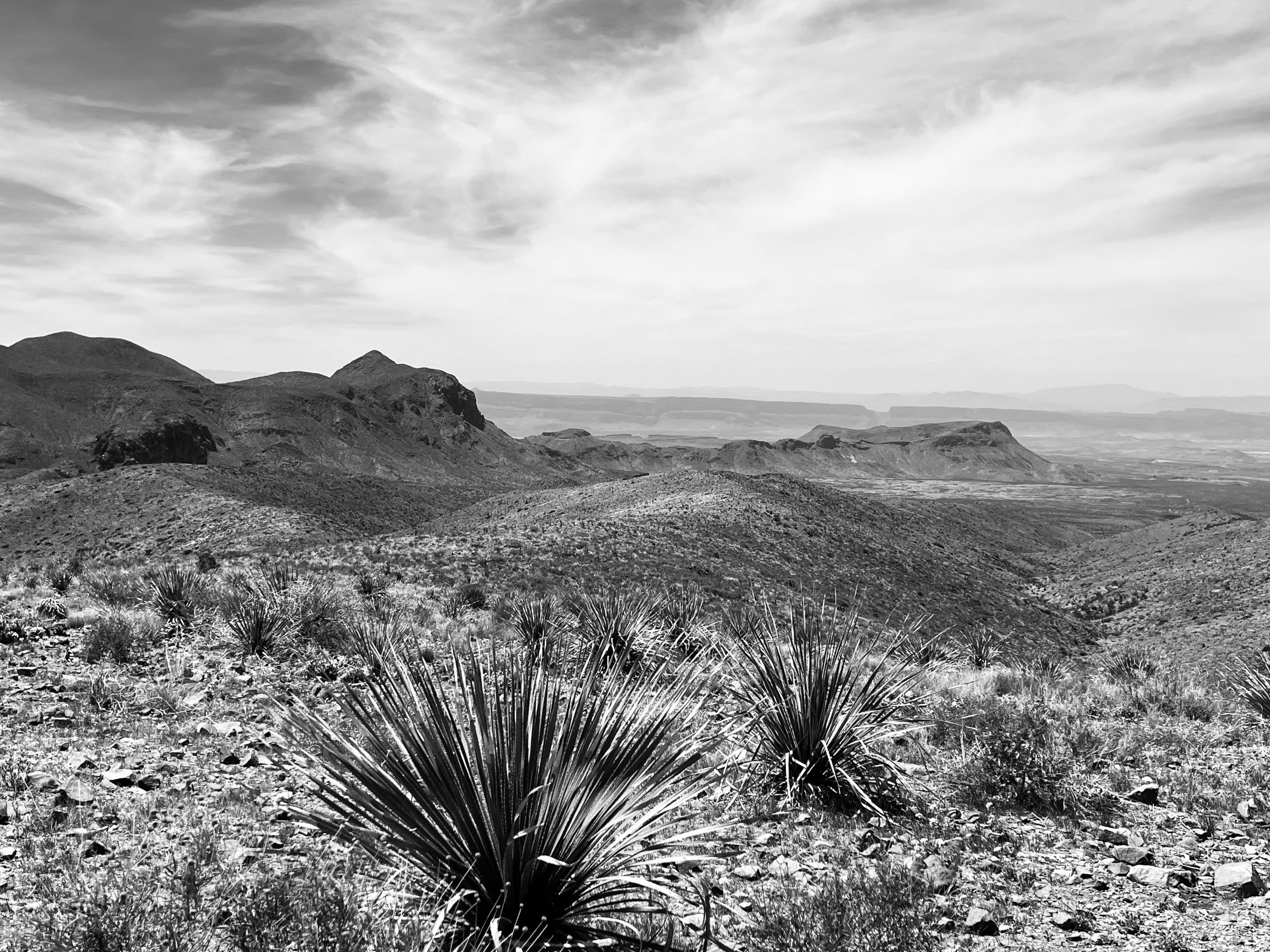
From there we continued down to Panther Junction Visitor Center with a quick stop at the entrance sign for the mandatory family photo. After stamping our passport, we walked around the quick 0.2 mile Panther Path at the visitor center to learn about area plants, and then on to see Balanced Rock. The Grapevine Hills Trail is a 2.2 mile moderate hike took us up to beautiful views of the surrounding dessert with some neat balancing rocks.

Note: The road out to Grapevine Hills is rough! Expect washboards and washouts. Even with Garrett’s country road experience, we drove slow in our high clearance vehicle. Be careful so you don’t get high centered.

That night, we stayed at another Trost hotel, The Gage. This stunning, iconic hotel is an experience in and of itself. 100% recommend if you have the opportunity. Also, make dinner reservations at 12 Gage for an unforgettable dinner to finish out your evening.
Day 4: Big Bend – Santa Elena Canyon + Ross Maxwell Scenic Drive
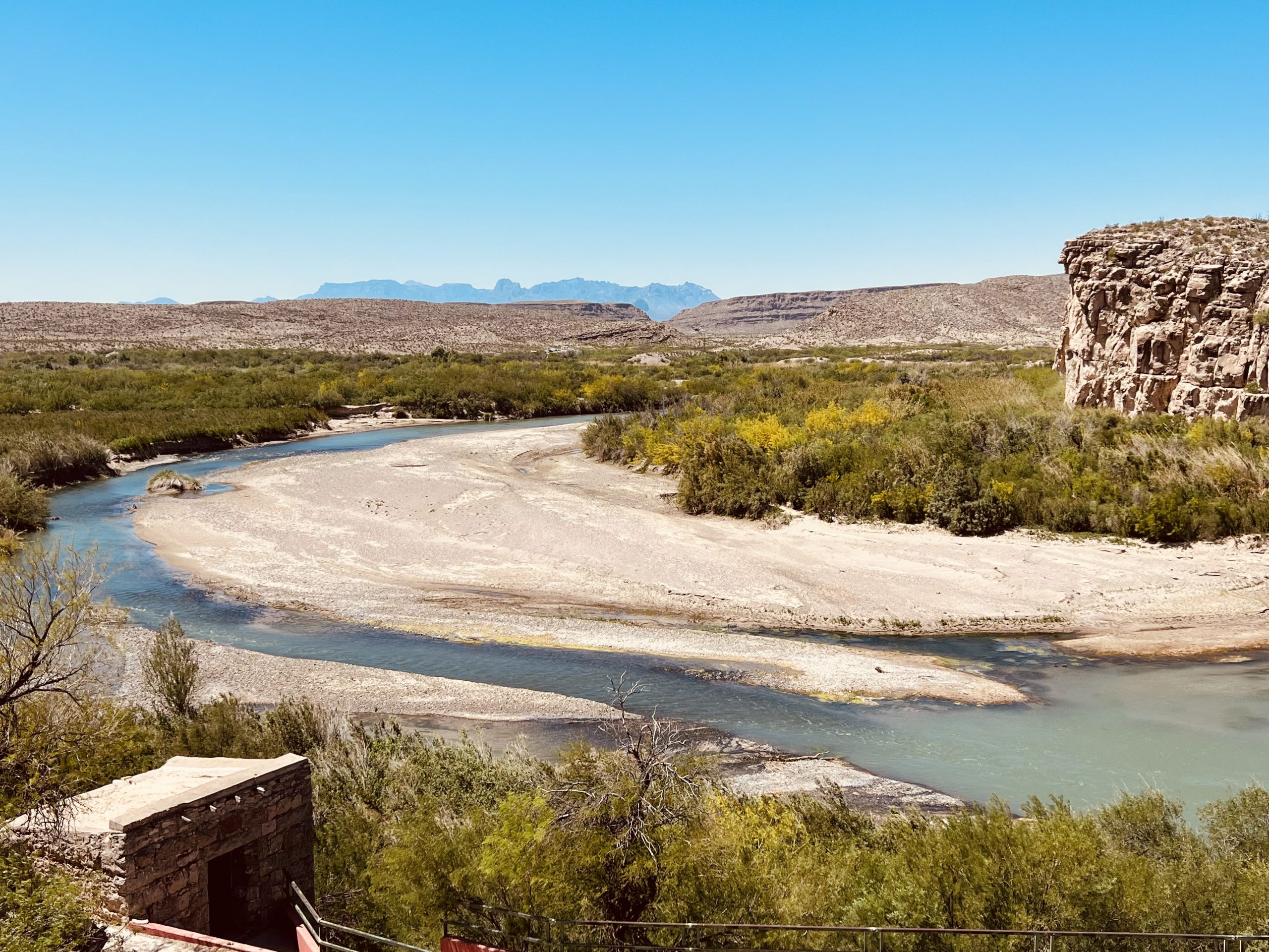
If you’ve ever seen a photo of Big Bend, it was probably of Santa Elena Canyon. This is where the Rio Grande slices through towering canyon walls, and the trail gives you views that you’ll think about for years.

Santa Elena Canyon Trail
- 1.6 miles round trip, 1 – 2 hours, moderate
- Bring water shoes!
- At the end of Ross Maxwell Drive, mile marker 30
You have two options with this day. Either drive all the way to Santa Elena Canyon first and then work your way back up the Ross Maxwell Scenic Drive or make your stops along the drive with plans to end at Santa Elena for sunset. Both are going to give you absolutely breathtaking views (and photos!), but we chose to start at Santa Elena for a chance to have the place to ourselves. We arrived just as it was starting to get light out, and there were already other people there, but it wasn’t too busy yet.

Depending on the water level, you may need to wade up to your waist, so bring water shoes and dry clothes for later. We were able to walk down Terlingua Creek just a bit to cross so we didn’t have to get soaked, but sometimes that isn’t an option. After we rounded the first bend, the views were spectacular. The towering 1000′ cliff faces illuminated by the rising sun were something I’ll never forget.
If you have the time, take the chance to play in the Rio Grande before heading back to our car, just make sure you don’t cross over the border.
Ross Maxwell Scenic Drive Highlights
Alright, confession. When I first mapped out this drive, I wrote down everything I wanted to see without really thinking about how long each one would take, just how far in between. I was really excited about it and told Garrett all the things we were going to do. He seemed a little skeptical and asked just how long we would be out that day. I proceeded to add it all up, then thinking about the hiking times, and realized I had planned about 29 hours worth of hikes…to be done in 1 day. Needless to say, that’s not really possible. From then on, I have learned to include those times in my calculations so that I don’t overextend us. Don’t be like the me of the past!
All that to say, below, I’ve included all of the stops on my original plan and which ones we actually did (⭐), so you can make your own choices in case something sounds more interesting to you.
- Dorgan-Sublett Trail
- 3 miles (5 minutes) from Santa Elena
- 0.5 mile one way, 30 minutes
- Short easy trail leads to ruins of several historic farmhouses
- Castolon Visitor Center
- 9 minutes from Dorgan-Sublett
- This was still closed when we visited, but there are historical exhibits here.
- Tuff Canyon Overlook
- 6 minutes from Castolon
- Again, when we visited the trail was closed due to rock fall and unstable slopes and I was so disappointed. The canyon looks stunning and this is a great place to see tuff rock, the hardened volcanic ash from long ago.
- ⭐ Mule Ears Viewpoint
- 8 minutes from Tuff Canyon (mile marker 15)
- ⭐ Goat Mountain Observation Point
- 3 minutes from Mule Ears
- Goat Mountain used to be a volcano. The tuff at Tuff Canyon is from one of its eruptions. My volcano-obsessed little boy thought it was pretty cool to see.
- Burro Spring Trail
- 7 minutes from Goat Mountain to Burro Spring
- The trailhead is 1 mile from the junction of Burro Mesa spur road on the left
- 2.4 miles round trip, 1 – 2 hours total
- (We opted to skip this one knowing what we had planned for the kids later)
- ⭐ Lower Burro Mesa Pour Off Trail
- 1 minute from Burro Spring road
- Trailhead is at the end of a paved side road forking off of Ross Maxwell
- 1 mile round trip, 30 minutes, easy
- This trail follows a gravel wash to the base of a 100 foot vertical channel, or pour off, from the mesa above.
- Pay attention to the weather. Flash floods are dangerous during the rainy season.
- ⭐ Sotol Vista Overlook
- 9 minutes from Lower Burro Mesa Pour Off
- You’re able to see Santa Elena Canyon in the distance
- ⭐ Homer Wilson Ranch/Blue Creek Canyon
- 1 minute from Sotol Vista
- Trailhead is a pullout on the east side of the road
- 0.3 miles along the trail is the old Homer Wilson Ranch
- If you are looking for ruins, there are better stops
- At the fork in the trail, go north to see red rocks, hoodoos, and pinnacles
- Upper Burro Mesa Trail
- 2 minutes from Homer Wilson
- Trailhead is a pull out along Ross Maxwell
- 3.6 mile round trip, 2 – 3 hours
- This is on my list for our next trip! There is an arch near the end that overlooks the pour off from Lower Burro Mesa. I’ve heard it’s amazing but be careful because it is slick.
- ⭐ Sam Nail Ranch
- 4 minutes from Upper Burro
- Trailhead is at mile marker 3
- 0.5 mile loop, 30 minutes
- This old homestead still has standing windmills
- ⭐ Cattail Falls Trail
- 8 minutes from Sam Nail Ranch
- I’m recommending this trail with a huge encouragement of “Leave it better than you found it,” and absolutely treat it with respect. This special area is a protected watershed used as drinking water. Do not wade in the pools. Walk on rocks as opposed to the soil so it isn’t damaged. There’s a reason the park has made it not easy to get to and isn’t maintaining the trail, but it is so beautiful and one that our kids still talk about. Ultimately, I’m saying, don’t f*ck this one up.
- 5.8 miles round trip, 3 -4 hours, moderate
- The first part of this hike is a 1.3 mile walk along a rocky road. This used to be open to get you closer to the trailhead, but it is now blocked off. Eventually, you’ll see some signs pointing up the road towards Window Trail via Oak Spring, Oak Spring, and Cattail Fall Tails and then reach another gate. Walk around the gate and keep on going for another 0.5 miles. Here, you’ll come to a horizontal trunk of an old oak tree that is perfect for a quick rest before turning right and heading up the trail.
- As you ascend up to the rim of Cattail Canyon wash and you’ll start to catch glimpses of waterfall below. As you get closer to the waterfall, you’ll have to scramble over boulders and small pools to continue. I held my breath as I watched my kids stretch their little legs across the gaps!
- When we finally made it to the 80′ spring fed water fall, we came upon our third oasis for this adventure. It was absolutely amazing and life changing for our family. This was the hike that made our kids fall in love with the outdoors.

The Night Sky

One of the things that makes Big Bend so unforgettable is its status as an International Dark Sky Park, home to some of the clearest, least light-polluted skies in the entire United States. The stars here don’t just “come out”—they explode across the sky in a way that feels ancient and almost otherworldly. Staying at StarStruck Glamping took that experience to the next level. With nothing but the quiet desert around us and panoramic views straight from our bed, we could watch the Milky Way stretch overhead, spot constellations we never see at home, and fall asleep under a sky that looked close enough to touch. It was one of the most peaceful, awe-filled parts of the entire trip, and a reminder of why nights in Big Bend are just as magical as the days.
Day 5: Big Bend – Rio Grande & Boquillas Day Trip
This day was one of the most memorable parts of our entire trip with a mix of river time, geothermal springs, authentic food and culture, and the kind of day your kids talk about for years.
After talking to a couple of outfitters, we booked with Hidden Dagger Adventures, and they made everything seamless. After a quick conversation with Tara, we decided on a canoe trip down the Rio Grande with a soak in the historic hot springs before crossing the border to Boquillas. You could coordinate this all on your own, but with Tara and Joe’s intimate knowledge of the area, we saw things we might have otherwise overlooked and personal guides to the best tacos and margaritas.

We met them for an early morning canoe launch. Paddling down the river between the towering cliff walls, we really saw the beauty of the Rio Grande. The blue water was mesmerizing as we saw babbling hot springs along the shore, “touched Mexico”, and learned about the history of the area. About half way through, we stopped at the historic Hot Springs district to soak in the old hot springs ruins.
After a little more paddling, we took out of the river and headed to Boquillas. After checking in at the border, we crossed the river and headed into town. Here, you can take a donkey, walk, or hitch a ride in the back of a truck. I fully intended on riding a donkey for an “authentic” experience, but the kids won with the back of the truck! In town, we explored the shops, ate amazing goat tacos, and took in the views before heading back to the US.
Tip: Make sure to bring your passport for a little international trip!
Bottom Line: White Sands, Carlsbad Caverns, Guadalupe Mountains, and Big Bend Itinerary: The Ultimate Southwest National Parks Road Trip
This trip is one we’ll measure others against for a long time. White Sands at sunrise, the silence of Carlsbad, a waterfall in the middle of the West Texas desert, goat tacos in Mexico, and falling asleep under the Milky Way. It’s a lot to pull off in five days, but it’s absolutely worth it. If you use this itinerary, we want to hear about it.
With light and love, Amber 🌿